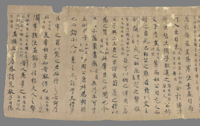
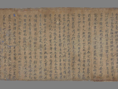
古文尚书禹贡
名称
古文尚书禹贡
编号
P.4033
年代
待更新
材质
墨繪紙本
语言
中文
现收藏地
法国国家图书馆
尺寸
简述
待更新
*以下文本内容由DeepSeek与腾讯混元生成,仅供参考。
### 白话文 大禹划分九州时,将永州、西上等地也包含在内。这四个国家位于荒服之外,属于流沙、西戎等边远地区。大禹治水时,从冀州的太岳山开始,经过太行山、恒山,直到碣石山入海。 雍州境内有朱圉山、鸟鼠山,向东延伸至太华山;豫州有熊耳山、外方山,淮水发源于桐柏山。泾水、渭水等河流的源头在嶓冢山(位于梁州),而荆山则属于荆州。 弱水向西流入合黎山,黑水向南流至三危山,再经龙门山、积石山。黄河从大伾山向北流,经过降水后分为九条支流(九河),最终汇入渤海。 漾水(汉江)从嶓冢山发源,向东流为沧浪水,再向南汇入长江。长江从彭蠡泽(今鄱阳湖)分为三支,其中北支流入震泽(今太湖),最终向东入海。
###Vernacular When Dayu divided Jiuzhou, Yongzhou, Xishang and other places were also included. These four countries are located outside the wasteland and belong to remote areas such as Liusha and Xirong. When Dayu controlled the water, he started from the Taiyue Mountain in Jizhou, passed through the Taihang Mountains and Hengshan Mountains, and reached the Jieshi Mountain into the sea. Yongzhou has Zhuyu Mountain and Niaosu Mountain, which extend eastward to Taihua Mountain; Yuzhou has Xionger Mountain and Waifang Mountain, and the Huai River originates from Tongbai Mountain. The sources of rivers such as Jingshui and Weishui are in Wuzhong Mountain (located in Liangzhou), while Jingshan belongs to Jingzhou. Weak water flows west into Heli Mountain, black water flows south to Sanwei Mountain, and then passes through Longmen Mountain and Jishi Mountain. The Yellow River flows northward from Daxian Mountain. After precipitation, it is divided into nine tributaries (Jiuhe) and finally flows into the Bohai Sea. Yangshui (Han River) originates from Wuzhong Mountain, flows eastward to become Canglang Water, and then flows south to the Yangtze River. The Yangtze River is divided into three branches from Penglize (now Poyang Lake), the northern branch of which flows into Zhenze (now Taihu Lake) and finally flows eastward into the sea.
# # # Le vernacle Lorsque Dayu a divisé Kyushu, Yongzhou et Xishang ont également été inclus. Ces quatre pays sont situés à l'extérieur de Warofu et appartiennent à des régions éloignées telles que les sables flottants et Saigon. Lorsque Dayu a contrôlé l'eau, il a commencé par la montagne Taiyue à Heizhou, passant par la montagne Taihang et la montagne Hengshan jusqu'à la montagne Qingshi dans la mer. Il y a des montagnes Zhuhuhuang et Bird Rat Mountain dans Yongzhou, qui s'étendent vers l'est jusqu 'au mont Taihua ; et Xionger Mountain et Waifang Mountain dans la préfecture de Henan. La source des rivières Jingshui et Weishui est dans la montagne Qingshan (située à Liangzhou), et Jingshan appartient à Jingzhou. L'eau faible s'écoule vers l'ouest dans la montagne Heli, l'eau noire s'écoule vers le sud jusqu'à la montagne Sanwei, puis à travers la montagne Longmen et la montagne Jishi. Le fleuve Jaune s'écoule vers le nord de la montagne Dahuang, après les précipitations, il est divisé en neuf affluents (neuf rivières) et finalement se jette dans la mer de Bohai. Le Yangshui (Friver Han) s'écoule à l'est dans le fleuve Changlangshui, puis se jette dans le fleuve Yangtsé au sud. Le fleuve Yangtsé est divisé en trois branches de Zhenze (aujourd 'hui le lac Poyang), dont la branche nord s'écoule dans Zhenze (aujourd' hui le lac Taihu) et finalement dans la mer à l'est.
##白語文 九州を分割する際には永州·西上なども含まれた。これら4カ国は砂漠の外に位置し、流砂や西ジョンなどの遠隔地に属している。大宇治水時、冀州の太岳山から、太行山、恒山を経て、海へと海へと至る。 永州朱玉山、鳥とネズミの山、東の太ワ山に拡張されている;豫州熊耳山、外国の山、淮水は桐柏山に起源を持つ。京水、河水などの河川の源流は、梁州にある劉塚山にあり、景山は荊州に属しています。 弱水は西に向かって合山に流れ、黒水は南に向かって三危山まで流れ、さらに山、石山を経る。黄河は大山から北に流れ、降水后に九つの支流(九河)に分かれ、に流れる。 漢江(漢江)は、李塚山から東に流れ、南に長江に注ぐ。長江は彭沢(現在の陽湖)から3つの枝に分かれ、北の枝は震沢(現在の太湖)に流れ込み、最終的に東に海に向かった。
查看更多
### 相关背景 1. **文献出处** 这段内容源自《尚书·禹贡》,是战国时期的地理文献,记载大禹划分九州、治理山川的传说。 2. **核心主题** - **九州划分**:冀州、雍州、豫州、荆州、梁州等地理范围 - **五服制度**:"荒服"指离王都二千五百里的边远地区 - **大禹治水**:开凿龙门、疏导九河等治水工程 3. **重要地名** - **太岳山**:今山西霍州,冀州与雍州分界 - **碣石**:渤海沿岸山丘(今河北昌黎) - **嶓冢山**:汉水发源地(今陕西宁强) - **三危山**:敦煌附近传说中的神山 4. **水系特征** - "九河"指黄河下游多条分支 - "沧浪水"为汉水古称 - "震泽"即太湖古名 5. **历史意义** 反映了战国时期对华夏地理的认知体系,为后世《汉书·地理志》等地理著作的源头。
###Related background 1. ** Literature source ** This content originates from "Shangshu·Yu Gong", which is a geographical document from the Warring States Period. It records the legend of Dayu dividing Jiuzhou and governing mountains and rivers. 2. ** Core theme ** - ** Division of Kyushu **: Jizhou, Yongzhou, Yuzhou, Jingzhou, Liangzhou and other geographical areas - ** Five-service system **:"Wasteland service" refers to remote areas 2,500 miles away from the capital - ** Dayu Water Control **: Water control projects such as digging Longmen and dredging Jiuhe River 3. ** Important place names ** - ** Taiyue Mountain **: The boundary between Huozhou, Jizhou and Yongzhou in Shanxi Province today - ** Jieshi **: Hills along the Bohai Sea (present-day Changli, Hebei) - ** Wuzhong Mountain **: The birthplace of the Han River (now Ningqiang, Shaanxi) - ** Sanwei Mountain **: The legendary sacred mountain near Dunhuang 4. ** Water system characteristics ** - "Jiuhe" refers to multiple branches in the lower reaches of the Yellow River - "Canglang Water" is the ancient name of the Han River - "Zhenze" is the ancient name of Taihu Lake 5. ** Historical significance ** It reflects the cognitive system of Chinese geography during the Warring States Period and is the source of later geographical works such as Han Shu·Geographical Records.
# # Contexte pertinent 1. * * Source de la documentation * * Ce contenu provient de Shangshu · Yugong, un document géographique de la période des Royaumes Combattants, qui enregistre la légende de Da Yu divisant Kyushu et gouvernant les montagnes et les rivières. 2. * * Thèmes principaux * * - * * Division de Jiuzhou * * : Heizhou, Yongzhou, Yuzhou, Jingzhou, Liangzhou et d'autres étendues géographiques - * * Système des cinq services * * : "Wangfu" désigne une région éloignée de 2500 miles de la capitale royale - * * Gouvernance de l'eau de Dayu * * : creuser Longmen, draguer la rivière Jiujiu et d'autres projets de gouvernance de l'eau 3. * * Noms importants * * * - * * Mont Taiyue * * : Huozhou, Jizhou et Yongzhou dans l'ouest du Shanxi - Les collines de la côte de la mer de Bohai (aujourd 'hui Changli, Hebei) - * - * * Les Trois Danger Mountain * * : la légendaire montagne de Dieu près de Dunhuang 4. * * Caractéristiques du système d'eau * * - « Neuf rivières » fait référence à de nombreuses branches du cours inférieur du fleuve Jaune - "Canglang Shui" est un ancien nom de l'eau de Han - "Zhenze" est le nom ancien du lac Taihu 5. * * Signification historique * * Il reflète le système de cognition de la géographie de la Chine pendant la période des Royaumes combattants et est la source des ouvrages géographiques tels que Han Shu · Geographie.
##関連の背景 1. **文献から ** この内容は、戦国時代の地理文書である『尚書·禹貢』に由来し、九州を分割し、山河を支配した伝説を記録している。 2. *** 主なテーマ ** - **九州区分 **:冀州、州、豫州、州、梁州などの地理范囲 - **五服制度**:“荒服”は王都から二千五百里離れた辺境地域を指す。 - ** 大宇治水**:龍門の開墾、九河の導水などの治水工事 3. **重要な地名** - ** 太岳山**:現在の山西省霍州、冀州と豫州の境界 - ** 石 **:沿岸の丘(の河北省昌) - ** 冢山**:水発祥の地(の宁强) - ** 三危山 **:敦煌近くの伝説的な山 4. ** 水の特徴 ** - “九河”とは黄河下流の複数の枝を指す - “水”は漢水と呼ばれる。 - “震沢”は太湖の古名 5. ** 歴史的な意味 ** 戦国時代の華夏地理の認知体系を反映し、後世の『漢書·地理志』などの地理著作の源流となった。
查看更多
中文
English
Français
日本語
妙法莲华经譬喻品第三
大智度论释经序品中摩诃萨义第四
佛画
千字文
救诸众生一切难经一卷 新菩萨经一卷
道经
有疑问?找AI助手!
链接已复制!
已收藏这幅作品到个人收藏室
AI小助手
欢迎来到数字藏经洞的历史宝库!我是你的智能助手,随时为你提供帮助和建议。这里有无数的宝藏等待你来发现,无论是文献、绢画、雕塑还是壁画,都可以尽情探索。请注意,回复内容由AI助手生成哦,仅供参考!记得保护隐私和核实信息,保持谨慎哦~
古文尚书禹贡的简单介绍
经卷为什么珍贵
莫高窟经卷是那个洞窟最多
稍等片刻,AI正在解锁知识宝藏
主页
检索
经卷
绢画
缀合目录
文献知见录
识文释字
我的藏经洞
收藏室
辅助研究
文字纠正与识别
云游戏
数字敦煌
数字敦煌资源库
数字敦煌开放素材库
敦煌学研究文献库
正在分析经卷中,请稍作等待…
辅助研究
保存笔记
纠正文字
纠正坐标
纠正
此识别结果由AI生成,欢迎一起反馈优化!
提交建议
扫码分享
打开微信,扫一扫